| Message/Author |
|
|
 Tom posted on Tuesday, August 30, 2005 - 08:48 pm Tom posted on Tuesday, August 30, 2005 - 08:48 pm
|
|
|
Hello - Marco, Gez and Myself have noticed real problems when you rotate DEM's by angles outside of 90 degrees - this means the GIS (arc in thsi case) has to interpolate cells, and can give a very 'lumpy' looking surface. This gives the model lots of extra 'work' and can lead to some strange rates of soil creep over time - as well as playing havoc with the fluvial erosion and deposition.
I'd advise only rotating in 90 deg chunks - or if you have to do otherwise you may have to do some smoothing - Marco worked out a way if I remember correctly,
THanks, Tom |
|
|
|
|
Hello, This is a question about DEM outputs.
Now some technical problems and questions arise. The scanning algorithm only returns -9999. As stated in the instructions I turned the DEM so that the outlet of the catchment is located on the right hand side of the data matrix. Still, I fear I have to many missing values (indicated by -9999) in my model. I send you a screenshot of the DEM so that you see what it looks like.
Do you think, that the catchment form is responsible for the erronous output?
 |
|
|
|
|
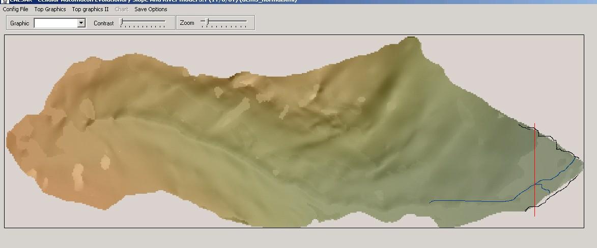
Hello, forgive, I have drawn on your DEM (above) to illustrate the point.
The stream network (blue line) wants to drain off the right hand side, and you have correctly orientated your DEM so the main direction of flow is to the right.
However, in this example above, the blue line goes off one side of the DEM, before the right hand edge - in this case the water and sediment output will not be collected at the RH edge.
One solution is to simply chop off the RH edge of the DEM (where the red line is). this can be done using the rather crude DEMeditor application that can be found here:
http://www.coulthard.org.uk/downloads/downloads.htm
OR you can build 'walls' (the black lines) to push all the flow to the RH edge. this can be done using the raster edit application that can be found here:
http://www.coulthard.org.uk/downloads/downloads.htm
The point where the DEM drains the RH edege MUST be on the RH edge - if there is one row of -9999's there, then it will stop the water and sediment making it out of the catchemnt. This is because the model will not route over -9999's to stop it moving material off the edge of the DEM.
I hope this helps explain things
Tom |
|
|
|
|
 |
|
|
|
|
THere is now an excellent tutorial on how to create DEM's for CAESAR, available here:
http://www.coulthard.org.uk/downloads/tutorial2.pdf
Tom |
|
|
| Back to top |
|