| Message/Author |
|
|
|
|
| Notes on version 6.2m. 5/10/2010 |
|
|
|
|
6.2m addresses some weaknesses in the area calculation funtion that may cause some diagonal artefacts.
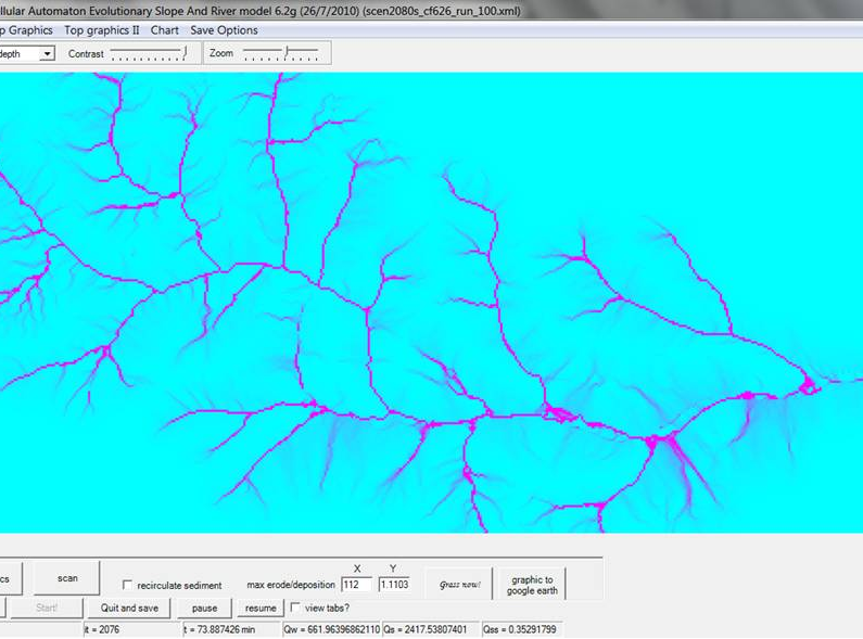
I was at a Geomorph workshop last week in Germany where I had c.30 PhD students all running CAESAR on a variety of their own and trial landscapes (several alpine catchments and even one in the dead sea which caused problems as it had �ve elevations!) but one problem became apparent that I have probably neglected for c.10-12 years...
The routine that calculates the drainage area (get_area2) scans 4 ways but only to the three cells in front. This can lead to diagonal artefacts in the drainage network that is calculated... Mostly I think these are OK, but at larger discharges (big floods) when there is loads of overland flow in the catchment these can cause unrealistic flow concentrations leading to diagonal erosion features. You may have seen these on some catchments you have simulated. See below...

In the last couple of days I�ve tried a couple of other methods, including:
- the D8 (steepest descent) which really concentrated flow too much and tended to �make� small channels.
- increasing the sweep width to 5 cells in front. This smoothed things nicely, but �reduced� the drainage area values in cells near the channel, so that when you added water at the edge of the scanned area (in the route functions) too little water was being added (leading to a c.20% shortfall in Qw).
- Dinfinity � which works really well but is (I thought) computationally expensive.
You need to sort all the elevations then work from highest to lowest routing discharge (or area) to the lowest group of neighbours according to relative height etc... After messing around for a few hours with bubble sorts etc.. I found a sort.array function in C# and it seems really really fast... so now its creating a much better drainage area map � and we�re avoiding all of the errors seen above (see below for new one).
Also, you can input a discharge record (in cumecs) directly via the rainfall file.
Tom |
|
|
|
|
| A final note: Remember that 6.2e had a major bug update that affected erosion and deposition: details here towards the end of this post: http://www.coulthard.org.uk/discus/messages/45/126.html?1279992386 |
|
|
|
|
| Owrking on some changes since - minor ones. Mainly linked to the re-circulation button. Should make all recirced sediment go intoa store that is then released as rapidly as possible. Proving a little awkward to do at present but making some progres.. |
|
|
| Back to top |