| Message/Author |
|
|
 Wolfgang Schwanghart (Wolfgang) posted on Tuesday, July 24, 2007 - 10:46 am Wolfgang Schwanghart (Wolfgang) posted on Tuesday, July 24, 2007 - 10:46 am
|
|
|
Hi Tom,
the catchment I am trying to model with CAESAR has a distinct channel. Yet flow somehow leaves the channel which leads to artificial structures in erosion/sedimentation patterns.
How can it happen that the water is not routed along the thalweg but leaves it?
I'd like to post a picture of the outcome of the model run, but there seems no way to post pictures, is it?
Best regards,
Wolfgang |
|
|
|
|
Hi Wolfgang,
hmm, water should not leave the channel unless there is an obstruction. You can post pictures here (as long as they are in web format (gig, jpeg, png) there are some notes on the formatting here: http://www.coulthard.org.uk/cgi-bin/discus/discus.cgi?pg=formatting#other
I look forward to seeing the images,
Tom |
|
|
| Wolfgang Schwanghart (Wolfgang) posted on Tuesday, July 24, 2007 - 01:45 pm
|
|
|
Tom,
ok... let's see whether image uploading works...
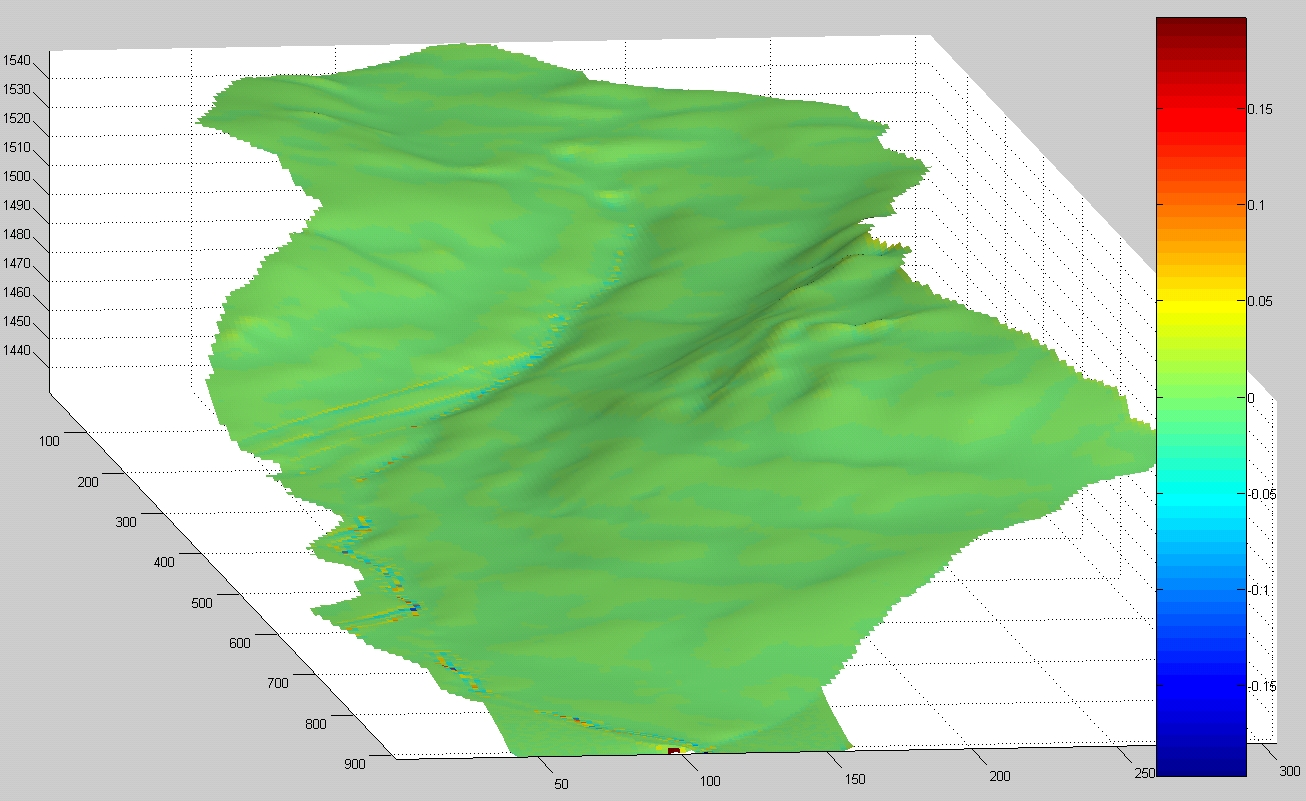
The image displays the elevation model after a 30 year run. The colors show the difference between the initial dem and the output elev.
Best regards,
Wolfgang |
|
|
|
|
| Thanks Wolfgang - are you talking about the lines about 1/2 way up - the diagonal ones (that appear to run horizontal here)? |
|
|
|
|
Now I've had lines like this before when you look at the drainage area display.. it may be due to the model not calculating the area drained OK. Just a couple of quick questions, which version of the model are you running? 5.7 or 5.8? As I did some work on this part in the latest version. If it is the latest version, then could you send me a zipped file of your DEM and the config file (.xml) with all the parameters in, so I can have a closer look?
Tom |
|
|
| Wolfgang Schwanghart (Wolfgang) posted on Tuesday, July 24, 2007 - 02:05 pm
|
|
|
| Yes, exactly. The scour and deposition patterns in general look plausible but the diagonal lines seem strange. |
|
|
| Wolfgang Schwanghart (Wolfgang) posted on Tuesday, July 24, 2007 - 02:08 pm
|
|
|
I used the 5.7 version. I'll try the new one and if it happens again, I'll take your offer and send you the file.
Thanks a lot,
Wolfgang |
|
|
|
|
Thanks for the files Wolfgang. For anyones information it appears that the 4 lines ht+=0.00001; in get_area2() were causing the problem. The catchment shown here had some quite low gradient sections, that allowed water to track diagonally with the drainage area calculation algorithm (that isnt perfect!),
Problem fixed and updated on the website (5.8b.cs)
Tom |
|
|
|
|
| OK, might not be 100% fixed.. will get back |
|
|
|
|
Right,
Lower down, there are some really low gradient sections, where water can quite easily veer off downwards in a diagonal section - especially if there is some erosion and deposition this can alter the capacity of the thalweg - causing in effect a mini avulsion. You could (with Rasteredit) create a mini wall along the bottom edge of your dem to stop the water and sediment going off the edge?
To stop the error, set the memory limit (numerical tab) to 1, and I would bump up the min Q to 0.05.
Got to go now, but see how that goes. New code now uploaded on the website
Tom |
|
|
| Wolfgang Schwanghart (Wolfgang) posted on Wednesday, July 25, 2007 - 10:34 am
|
|
|
Good morning, Tom,
I followed your advice. I 'built' a 0.5 m wall around the whole catchment and did the changes in the numerical options. Still the flow routing shows the same patterns.
I have the suspicion that these problems may partly arise from my DEM, which is hydrologically correct (no sinks), but which exhibits some oversteepenings and erroneous bumps that may be eroded during the first rainfall event and whose deposits may obstruct the channel course.
Best regards,
Wolfgang |
|
|
|
|
Hi wolfgang - thanks for the images.
Yes, it may be the DEM - what we do here when developing a DEM is to cut a channel 1m deep (for example) into the DEM before using it. We do this using the arc-hydro tool kit freely available for ARC-GIS.
If you search the other posts (on dem creation?) there should be a link to an instruction leaflet on this.
You could also try changing the sweep width to 1 or 2? But I suspect if you give the model a small channel to start with it should erode into that.
Failing that, try running many smaller floods instead of large ones so that the channel has more of a chance to form.
If that does not work let me know,
Tom |
|
|
| Wolfgang Schwanghart (Wolfgang) posted on Wednesday, July 25, 2007 - 02:56 pm
|
|
|
Hi Tom,
it looks much better now
I cut the channel 1m deep and set the sweep width to 3 and decreased the first few floods in their magnitude.
Thanks a lot,
Wolfgang |
|
|
|
|
That looks better,
Glad it works,
Tom |
|
|
| Back to top |